Nome Census Area Property Records
Nome Census Area property records are managed by the Nome Recording District, which is operated by the Alaska Department of Natural Resources, Division of Mining, Land and Water. This office handles all recorded instruments for the Nome region, including deeds, mortgages, liens, mining claims, UCC filings, and plat maps. The recording office is in Nome at 113 Front Street, and the Nome Assessor is at 102 Front Street. If you need to search property records for land in this part of western Alaska, these two offices are your main contacts. Some record types are also searchable online through the state's land records system.
Nome Census Area Overview
Nome Recording District
The Nome Recording District is the main office for all property record filings in Nome Census Area. The office is run by the Alaska Department of Natural Resources, Division of Mining, Land and Water. The mailing address is P.O. Box 1349, Nome, AK 99762. The physical location is 113 Front Street, Nome, AK 99762. You can call the office at (907) 443-2830.
The Nome Recording District keeps records of all instruments that affect real property in the area. These include deeds, mortgages, liens, Uniform Commercial Code filings, mining claims, easements, rights-of-way, and plat maps. When a property changes hands, the deed must be filed here to be legally effective against third parties. The recording district indexes all documents by the names of the grantor and grantee, making it possible to search for all documents involving a specific person or entity.
Alaska uses a grantor and grantee indexing system. This means documents are filed under the names of the parties, not just the parcel address. If you are tracing the history of a property, you need to search through successive owners by name. The Alaska land records search at dnr.alaska.gov/landrecords lets you do this online. The full recording district list is at dnr.alaska.gov/ssd/recoff/distlist.
| Office | Nome Recording District - Alaska DNR Division of Mining, Land and Water |
|---|---|
| Physical Address | 113 Front Street Nome, AK 99762 |
| Mailing Address | P.O. Box 1349 Nome, AK 99762 |
| Phone | (907) 443-2830 |
| Online Search | dnr.alaska.gov/landrecords |
Nome Assessor and Tax Records
The Nome Assessor provides information on assessed values, property descriptions, and ownership for tax purposes. The Assessor's office is at 102 Front Street, Nome, AK 99762, and can be reached at (907) 443-2830. This office is separate from the recording district but covers related ground. While the recording district holds deed and lien filings, the Assessor tracks current ownership and value for tax purposes.
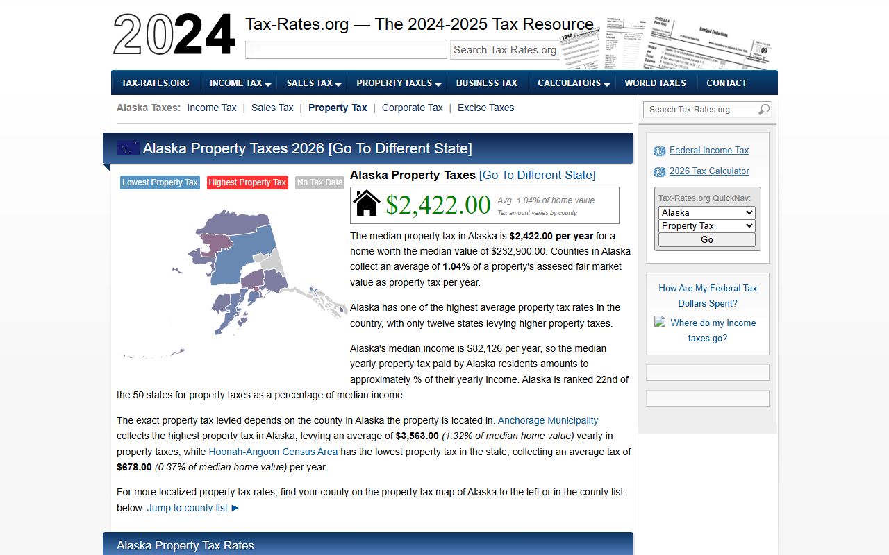
Assessment records show the appraised value assigned to each parcel and the tax amount based on that value. The median property tax in Nome Census Area is $1,948 per year. This reflects conditions in the Nome area and varies by parcel size, location, and improvements. The tax rate and assessment process follow Alaska state law, which requires that assessments reflect full and true market value.
Nome Census Area is an unorganized area, which means property tax structures here differ from those in organized boroughs like Matanuska-Susitna or Kenai Peninsula. The city of Nome itself has its own assessor and levies local property taxes within city limits. For properties outside the city of Nome but within the census area, the tax structure may be different. Contact the Nome Assessor's Office directly to confirm tax status for a specific parcel.
Note: For delinquent tax information or questions about tax exemptions, contact the Nome City offices directly. The assessor phone number serves both recording and assessment inquiries at the shared contact line.
Searching Nome Census Area Property Records
You can search for Nome Census Area property records online or in person. Online searches are useful for basic information. In-person visits to the Nome Recording District office at 113 Front Street let you inspect files directly and get certified copies on site.
The Alaska land records search at dnr.alaska.gov/landrecords is the online access point for recorded instruments. You can search by grantor name, grantee name, document type, or recording date. This covers deeds, mortgages, liens, and other instruments filed with the Nome Recording District. When you find a document, you can view basic identifying information and request a copy.
To request certified copies by mail, write to the Nome Recording District at P.O. Box 1349, Nome, AK 99762, and include the recording number or a description of the document you need. Fees are set by state statute: $20 for the first page of a document and $5 for each additional page for most documents. Certified copies cost $5 per document plus copy fees. The full fee schedule is posted at dnr.alaska.gov/ssd/recoff/Fees.
For tax and assessment data, the Nome Assessor at 102 Front Street, (907) 443-2830, can help you find assessed values and ownership information for parcels in the Nome area. There is no comprehensive online assessment search tool for Nome the way there is for larger boroughs like Mat-Su, so direct contact with the office is often the best approach.
Property record searches for Nome Census Area can be done through the Alaska DNR land records system online or by visiting the Nome Recording District office at 113 Front Street.
Nome Census Area Property Records Contents
The Nome Recording District holds a range of document types that affect real property in the area. Each type serves a different function in the real estate system.
Deeds are the most common recorded document. They transfer ownership from one party to another. A recorded deed establishes who currently holds title to the property and creates a link in the chain of ownership going back through time. Mortgages and deeds of trust show financial claims against property. When a loan is taken out using real estate as collateral, the lender records a mortgage to protect its interest. When the loan is paid off, a release of mortgage or satisfaction is recorded to clear the title.
Mining claims are a significant category in Nome's recording district, reflecting the area's history and ongoing activity in placer gold mining on the beaches and rivers of the Seward Peninsula. Mining claim filings record the location, boundaries, and ownership of mineral claims. These are separate from surface property rights and exist alongside regular land records. UCC filings, easements, and rights-of-way round out the types of instruments kept in the district.
Plat maps show how land is divided into surveyed lots within a specific area. When a subdivision is platted, the plat is recorded and becomes the official record of lot lines and easements for that development. If you are researching a parcel in Nome's city limits, the plat map shows the lot boundaries and any easements that run with the land.
Nome Census Area property records include deeds, mortgages, mining claims, plats, and liens maintained by the Nome Recording District for all lands in the recording area.
Alaska Property Law for Nome
Property recordings in Nome Census Area follow Alaska Statute Title 40, Chapter 17. This law sets the requirements for how documents must be prepared before they can be recorded, what fees the recorder charges, and the public nature of recorded documents. All recorded instruments become part of the public record. Anyone can request copies without having to explain their reason.
The recording act in Alaska protects good-faith buyers and lenders. If you buy a property and record your deed, you have priority over anyone who held an earlier unrecorded interest in the same property. This is why recording matters in every transaction. Once a deed or other instrument is indexed in the Nome Recording District, it gives constructive notice to all future parties dealing with that parcel.
To be accepted for recording, documents must be legible, meet margin requirements, and include the names of all parties and a legal description of the property. If a document does not meet these standards, the recorder can return it without recording. Prepare documents carefully and review the requirements before submission.
Recording fees are established by statute. The standard rate is $20 for the first page and $5 for each additional page. Certified copy fees are $5 per document plus copy charges. Contact the Nome Recording District at (907) 443-2830 or visit dnr.alaska.gov/ssd/recoff/Fees for the current schedule.
Communities in Nome Census Area
Nome Census Area includes the city of Nome and a number of smaller communities across the Seward Peninsula and Norton Sound region. Smaller villages include White Mountain, Golovin, Elim, Koyuk, Shaktoolik, Unalakleet, Shishmaref, Wales, Teller, and others.
None of the communities in Nome Census Area currently meet the population threshold for a dedicated city page on this site. For property records for any parcel in the area, use the Nome Recording District at 113 Front Street or search online through the Alaska DNR land records system.
Nearby Census Areas
These areas border or are located near Nome Census Area. Each uses the Alaska state recording system for property documents.