Find Property Records in Copper River Census Area
Copper River Census Area property records are held by the Alaska Department of Natural Resources through its centralized state recording system. This unorganized region of Interior Alaska does not have a local recorder, so all deeds, mortgages, liens, and land documents are filed with the DNR's recording districts that cover the Glennallen area. Searching Copper River Census Area property records means going to the state's online land records system or contacting the DNR office that covers your specific part of the census area. This guide walks you through what you need to know to find and access those records.
Copper River Census Area Overview
Recording Districts for Copper River Census Area
Property recording in the Copper River Census Area is handled by the Alaska DNR Recorder's Office, which administers 34 recording districts across the state. Since the Glennallen region and surrounding communities are part of Alaska's Unorganized Borough, there is no local census area recorder. The DNR's recording district system is the only place to file and look up property documents for this area.
The Copper River Census Area falls under two recording districts depending on the location of the property. Communities along the Glenn Highway corridor are recorded in the Third Recording District. Properties in the coastal areas of the census area fall under the Fourth Recording District. Both districts are managed through the DNR's office network. The Anchorage Recording District office at 550 West 7th Ave., Suite 108, Anchorage, AK 99501-3564, phone (907) 269-8876, serves as the main access point for recorded documents in both of these districts. Documents are indexed together in the statewide system and are searchable online.
| Recording Authority | Alaska DNR Recorder's Office |
|---|---|
| Anchorage Office Address |
550 West 7th Ave., Suite 108 Anchorage, AK 99501-3564 |
| Phone | (907) 269-8876 |
| Recording Districts Covered | Third (Glenn Highway communities), Fourth (coastal areas) |
| Online Search | dnr.alaska.gov/landrecords |
Searching Copper River Census Area Property Records
The DNR provides a free online database where you can search Copper River Census Area property records. Go to dnr.alaska.gov/landrecords to start. You can search by owner name, document number, or legal description. The online index covers documents recorded from 1970 forward. Older records require an in-person request at the Anchorage office.
The DNR land records system is the primary public database for property documents in the Copper River Census Area, offering name and legal description searches across all recording districts.
Once you find a document in the index, you can view the image by logging into a free DNR account. The system shows the grantor and grantee names, recording date, serial number, and the type of document. For full document text including legal descriptions, lot lines, and terms of any liens or mortgages, you need to open the image in your account.
For in-person searches, visit the Anchorage office. Staff can look up documents in the index and help you navigate the system. Copy fees apply. Call (907) 269-8876 ahead of your visit to confirm hours. You can also mail a written request with the names or document numbers you need. Include a check for the applicable copy fees.
Recorded instruments for Copper River Census Area land include ownership transfers, debt instruments, and encumbrances, all filed in the DNR's statewide index system.
Fees for Recording and Copying Property Documents
Alaska uses a uniform DNR fee schedule for recording any property document statewide. This applies to all recording districts, including those that cover the Copper River Census Area. Recording fees are set by Alaska Statute 44.37.025 and by 11 AAC 05.200. You do not pay different rates based on the census area where the land is located. The fee structure is the same across the board.
The recording fee is $20 for the first page of a document and $5 for each additional page of the same instrument. If a document needs more than six names indexed, each additional name costs $2. Documents that do not meet the standard margin or format rules carry a $50 non-standard document fee on top of the regular recording charge. Certification of a copy costs $5 per document. Plain copies cost $1.25 for the first page and $0.25 per additional page. Certified copies cost $5 per document for the certification plus the copy rate per page.
Note: Checks for recording fees must be made payable to the Department of Natural Resources.
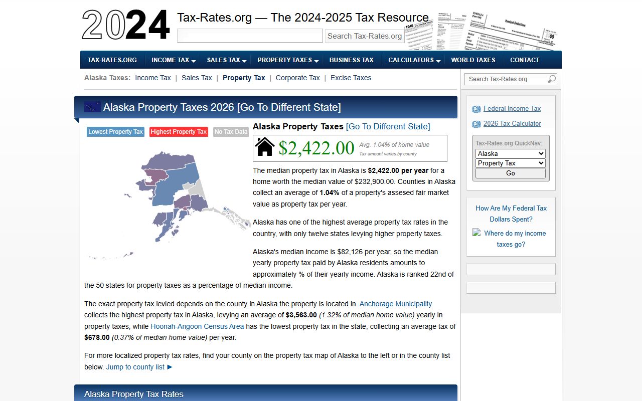
Property Taxes in Copper River Census Area
The Copper River Census Area is an unorganized census area and does not levy borough-level property taxes. Property taxation in Alaska is handled at the borough level for organized boroughs only. Since this area falls within the Unorganized Borough, there is no local mill rate or assessed value tax bill from a borough government. State land assessments may apply in limited situations, but most private landowners in this area do not pay a census area-level property tax.
If your land is within the boundaries of an incorporated city inside the Copper River Census Area, that city may have its own property tax. Cities can levy taxes within their limits regardless of whether the surrounding area is organized or not. Contact the city directly to find out if a city-level property tax applies to your parcel. For state-owned or federal land, different rules apply, and those parcels are generally exempt from local taxation.
What Property Records Show for This Area
Property records in the Copper River Census Area follow the same format as all Alaska recorded instruments. A warranty deed shows the grantor, grantee, legal description, consideration paid, and the signatures of the parties. A quit claim deed does the same but without a warranty of clear title. Mortgages and deeds of trust name the lender, borrower, the amount secured, and the property pledged. All must be acknowledged before a notary and meet DNR format requirements before they can be recorded.
Liens recorded against Copper River Census Area property appear in the grantor index under the name of the property owner. This includes federal tax liens, state tax liens, mechanic's liens, and judgment liens. Easements affecting the land show who holds the easement, its purpose, and the area it covers. Plat maps record subdivision layouts and lot boundaries. UCC financing statements can also be recorded here when they apply to fixtures or real property interests.
The statewide index at dnr.alaska.gov/landrecords is the starting point for finding any of these document types. The legal framework for recording is found in Alaska Statute Title 40, Chapter 17, which governs the state's recording system and sets the rules for what must be recorded and how it must be done.
Cities Near Copper River Census Area
The Copper River Census Area is a largely rural region. The community of Glennallen is the main hub but is not an incorporated city. Nearby qualifying cities with their own property record resources include Valdez to the south and Anchorage further west.
Other communities in the Copper River Census Area include Glennallen, Kenny Lake, Chitina, and Slana. Property documents for all of these areas go through the DNR's recording district system.
Nearby Boroughs and Census Areas
Several other Alaska jurisdictions border the Copper River Census Area. Check the correct recording district for each area before filing or searching property documents.